


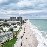
 Alarming report: 86% of shoreline critically eroded
STORY BY STEVE CHAMBERS (Week of May 21, 2026)
Nearly 90 percent of the barrier island shoreline is critically eroded, and sector 5, a 3-mile stretch that includes Central Beach, is in the worst shape, according to a new county report.
A critically eroded shoreline is one “where natural processes or human activity have caused or contributed to erosion and recession of the beach or dune system to such a degree that upland development, recreational interests, wildlife habitat, or important cultural resources are threatened or lost.”
The findings come from a draft of the county’s Beach Preservation Plan Update, which was released in April and represents the first systematic, scientific analysis of the entire 22-mile coastline ever undertaken by Indian River County.
Put together by Taylor Engineering, the 130-page report considers five factors, including erosion trends, storm modeling and the proximity of development to the dune line, to come up with a comprehensive flood and storm damage risk score for each of eight planning sectors.
Sector 5, which stretches from Surf Lane in Indian River Shores to about the middle of the Riomar Country Club golf course, received the highest score, a 41.
Not an ideal finding, since that’s the stretch of shoreline that defines Vero Beach, encompassing popular parks, an array of ultraluxury homes and condos, and the Central Beach business and hospitality district where many island landmarks, hotels, restaurants and shops reside.
County officials say the new ranking system is intended to help direct shoreline management efforts toward areas facing the greatest erosion pressure and infrastructure exposure.
“Our new risk-analysis matrix is another tool in the county’s toolbox,” said Coastal Resource Manager Quintin Bergman. “It will assist the Beach Program in directing limited resources toward the areas with the most threatened infrastructure.”
In Central Beach, dunes, roads and buildings sit unusually close to an increasingly stressed shoreline, according to project engineers, with the shortest average buffer of any sector between infrastructure and the shoreline – just 150 feet from the mean high-water line. By comparison, Sector 6, which extends from the Riomar golf course to south of the city limit, averages nearly 500 feet.
That section, bordered by South Beach Park and Castaway Cove, is in a shallow bay that extends to a point opposite St. Edward’s school. The bay catches sand flowing south with prevailing currents causing the beach to get wider each year instead of narrower.
The beach in that section gained 31 feet in width between 2019 and 2024, the timeframe of the report, measured from the waterline to the base of the dunes.
Sector 6 has a risk score of 16, the lowest in the report, tied with Sector 8, the southmost planning section, which stretches from south of The Moorings to the St. Lucie County line. That section also has an accreting beach, one that is getting wider naturally.
Islandwide, leaving out sector 6, the ocean is edging about a foot closer to A1A every two and half years on average, according to the report, and the dune line retreated as much as 31 feet from the water during the five years covered by the report.
The mean highwater line is moving west, toward houses and roads, because of erosion and sea level rise. According to the National Oceanic and Atmospheric Agency (NOAA), the sea along Vero’s coast will rise between 8 and 18 inches by 2050. The agency predicts a sea level 3 to 5.5 feet higher by the end of the century.
Neither set of numbers is good news for Central Beach, where risk of storm damage is already high, according to the report. Much of the development in Central Beach sits directly behind, or in some cases effectively on top of, the primary dune feature. In addition, county data shows that 36 percent of the shoreline in sector 5 is protected by armoring such as seawalls because of the proximity risk between the ocean and nearby infrastructure, and seawalls are known to accelerate beach erosion.
The plan points to three forces converging on Central Beach: persistent erosion, high-value infrastructure, and limited space between the two, leaving little margin for error.
Waves sometimes lap against the seawall at Sexton Plaza, where the narrow beach can disappear beneath turbulent saltwater during storms, and wind-driven water has damaged or destroyed boardwalks at Humiston Park and Conn Beach and repeatedly washed out parts of Ocean Drive.
A sense of the pressure nature puts on island beaches can be seen in the Historical Coastal Conditions section of the report, which notes that between 1980 and 2022 there were 2,800 days when surf 5 feet or higher crashed on the shore, gobbling up sand and pushing dunes back.
“Coastline stability doesn’t happen by chance,” Bergman said. “It’s the result of ongoing monitoring and active management which includes nourishment, dune restoration, and sand bypassing. Without these efforts, erosion would outpace recovery, and the beach and dune would gradually narrow, reducing storm protection and the space people and wildlife depend on.”
For decades, Indian River County has relied on an active beach management strategy. Sand is mined or dredged, transported and placed along the shoreline. Dunes are rebuilt. Sediment is bypassed around Sebastian Inlet to maintain the natural flow of sand to the northern island that would otherwise be interrupted.
Those efforts have stabilized large portions of the shoreline, reduced storm impacts and preserved both recreational space and property, but they require continuous intervention, coordination and funding. In Central Beach, they are offsetting forces that would otherwise push the shoreline back – in the location where the stakes are the highest.
According to the county’s Beach Preservation Plan update, beaches in Indian River County generate roughly $248 million annually and support nearly 9,000 jobs tied to tourism and coastal activity. The majority of that activity is concentrated along the island’s most developed stretches, especially Central Beach.
Protecting the shoreline is not just about preserving sand. It is about preserving the economic engine built on top of it.
“One of the main benefits of Ocean Grill is the location, especially the views of the ocean,” said Kyle Smith, night manager at landmark Ocean Grill in Sexton Plaza. “We’re known for those views, and we’re closer to the water than anyone else around here.”
At the same time, the conditions shaping the shoreline are shifting. County consultants, relying on NOAA and U.S. Army Corps of Engineers projections, estimate that portions of the shoreline could retreat roughly 49 feet by 2050 and more than 200 feet by 2100 if no management actions are taken.
If that happened in Central Beach, Waldo’s Restaurant, Ocean Grill and Mulligan’s Beach House would all be in the ocean.
County officials describe sea level rise not as an immediate catastrophe, but as a long-term stressor that gradually reduces the natural buffer beaches provide to roads, utilities, homes and public access points.
Higher baseline water levels allow waves and storm surge to reach farther inland, reducing the effective width of the beach and increasing pressure on dunes and structures. In areas with wider beaches and greater setbacks, that pressure can be absorbed more naturally.
In Central Beach, there is less room.
That does not mean disaster is looming in the near term. It does mean the system, already being maintained at significant effort and expense, is getting easier to disrupt. A storm that might once have been manageable may now push farther inland. A shoreline that once recovered naturally may now require intervention.
The county’s response, at least for now, is not to change its strategy but to refine it.
Along with the current practice of beach renourishment, the report examines eight other shoreline management strategies, including seawalls, breakwaters, groins – rock jetties that protrude into the sea – geotubes and artificial reefs that have been used elsewhere to protect coastlines.
The plan concludes that beach and dune nourishment remains the most effective and practical approach to maintaining shoreline stability, recommending continued investment in sand placement, vegetation management and sediment coordination with regional partners.
But the county could employ more dramatic means if necessary at some point in the future, including relocating structures and dumping more massive loads of sand to push beaches hundreds of feet past the current waterline.
Historically, the county has favored smaller “non-impacting” sand nourishment projects designed to avoid damage to nearshore reef systems. Those projects typically place between 8 and 20 cubic yards of sand per linear foot of beach.
Larger-scale projects, similar to those carried out in places such as Juno Beach and Miami Beach, could dramatically widen portions of Central Beach but would risk burying sensitive reef habitats offshore. According to county officials, those types of projects would be challenging, likely requiring extensive environmental mitigation, regulatory review and costly permitting.
But recent county data suggests the smaller-scale approach may not be sufficient to keep pace with long-term erosion rates.
“We may evaluate larger-scale nourishment templates that include a wider beach berm,” Bergman said. “This would be a more complex impacting design that requires careful study of our offshore resources.”
The county recently completed its latest renourishment effort in Central Beach and is now conducting permit-required monitoring that includes beach escarpments, shorebird and sea turtle nesting, and offshore sand movement surveys extending roughly a quarter mile into the Atlantic.
“Sector 5 is identified as our most at-risk sector, but it’s part of a 22.4-mile system,” Bergman said. “We have to balance management efforts across the entire coastline while addressing the areas at greatest risk.”
Change at the beach is incremental and for now the shoreline looks much as it always has at a casual glance. But the data suggests something more dynamic underneath. Stability maintained through effort. Risk managed rather than removed.
For decades, the county’s strategy has been incremental. Careful nourishment. Targeted dune work. Minimal environmental disruption.
The concern now is whether erosion and sea-level rise will continue behaving incrementally in return.